Introduction to Coastal Navigation
Navigating Safely Within Sight of Land
What is Coastal Navigation?
Coastal navigation is the most common and widely practiced form of navigation, used every day by recreational boaters, sailors, and professional mariners operating near land. It is the art and science of guiding a vessel safely along a coastline — typically within 20 to 30 nautical miles of shore — using charts, visual references, and navigational aids.
At its core, coastal navigation relies on what you can see and measure in your immediate surroundings. Landmarks such as headlands, buildings, and towers; aids to navigation (ATON) like buoys, lights, and lighthouses; and charted features including depth contours and hazards all provide continuous reference points. These allow a navigator to determine position with confidence and make informed decisions in real time.
Coastal navigation is especially important because of the complex and dynamic environment near shore. Shoals, rocks, reefs, shifting sandbars, fishing gear, and vessel traffic all require constant attention. Navigation in these areas is active and continuous — positions are checked frequently, particularly when approaching harbors, transiting narrow channels, or dealing with strong tidal currents.
This close interaction with the environment is what defines coastal navigation. Rather than long periods between updates, it demands ongoing situational awareness and frequent course adjustments. The advantage is that there is an abundance of information available to include visual cues, chart data, and onboard instruments which, when used together, provide a highly accurate picture of your position and movement.
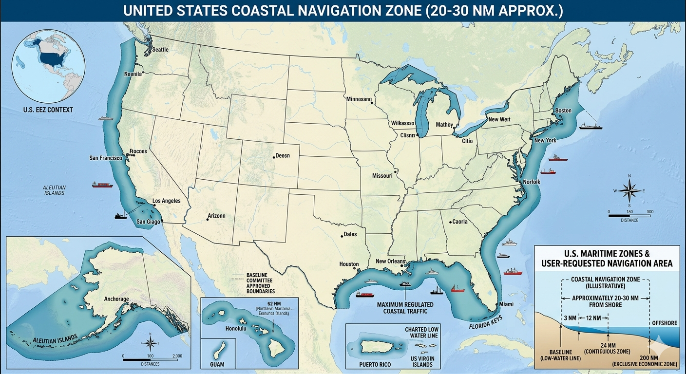
A good rule of thumb: if you can see the land or pick up coastal aids to navigation on radar, you are in the coastal navigation zone. The moment you lose those references, you are transitioning to offshore navigation.
Never assume coastal waters are safe simply because land is visible. Some of the most dangerous sailing conditions — shallow water, strong tidal streams, heavy commercial traffic — occur close to shore.
What is the typical range from shore that defines the coastal navigation zone?
Which of the following best describes what makes coastal navigation active and continuous?
Two Approaches: Traditional and Electronic
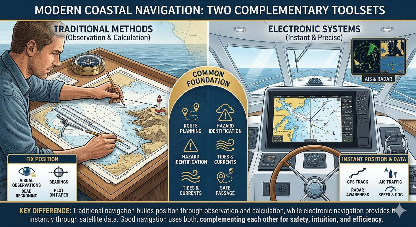
Modern coastal navigation is built around two complementary tool sets: traditional (manual) methods and electronic navigation systems. Most navigators use a blend of both, choosing the approach that best fits their style, goals, and the demands of the situation.
Traditional navigation centers on the paper chart, the magnetic compass, and simple plotting tools. The navigator works through bearings, fixes, dead reckoning, and visual observations to build a clear mental and plotted picture of the vessel's position. For many, this approach is not just practical — it's engaging. It provides a deeper understanding of how navigation works and how the boat interacts with wind, current, and the charted environment. In performance sailing or more demanding conditions, these skills can also support faster interpretation and decision-making.
Electronic navigation, on the other hand, delivers speed, convenience, and precision. GPS-enabled chart plotters provide continuous real-time positioning, while systems like AIS and radar add layers of awareness about traffic and surroundings. Route planning, course adjustments, and estimated arrival times can all be calculated instantly, making electronic navigation the default choice for most modern sailors.
Importantly, both approaches share the same foundation. Whether you are working on paper or on a screen, you still need to plan your route, identify hazards, account for tides and currents, and think ahead about how the passage will unfold. Good navigation is not just about knowing where you are — it's about knowing where you're going and how you will get there safely.
The key difference between the two methods is how you determine and update your position. Traditional navigation builds position through observation and calculation, while electronic navigation provides it instantly through satellite data. Everything else to include route planning, hazard avoidance, timing, and decision-making, remains largely the same.
Rather than framing one method as a backup to the other, it's more useful to see them as different ways of thinking about navigation. Some sailors are drawn to the hands-on, analytical nature of traditional techniques; others prefer the efficiency and clarity of digital systems. In practice, using both together can be powerful, traditional methods build intuition and situational awareness, while electronics streamline execution and reduce workload.
Make it a habit to plot at least one manual fix per watch, even when your chart plotter is working perfectly. It keeps your skills sharp and provides an immediate cross-check of your electronic position.
Over-reliance on GPS is one of the leading causes of groundings in recreational sailing. Always verify your electronic position against visual references when they are available.
The Navigator's Toolkit
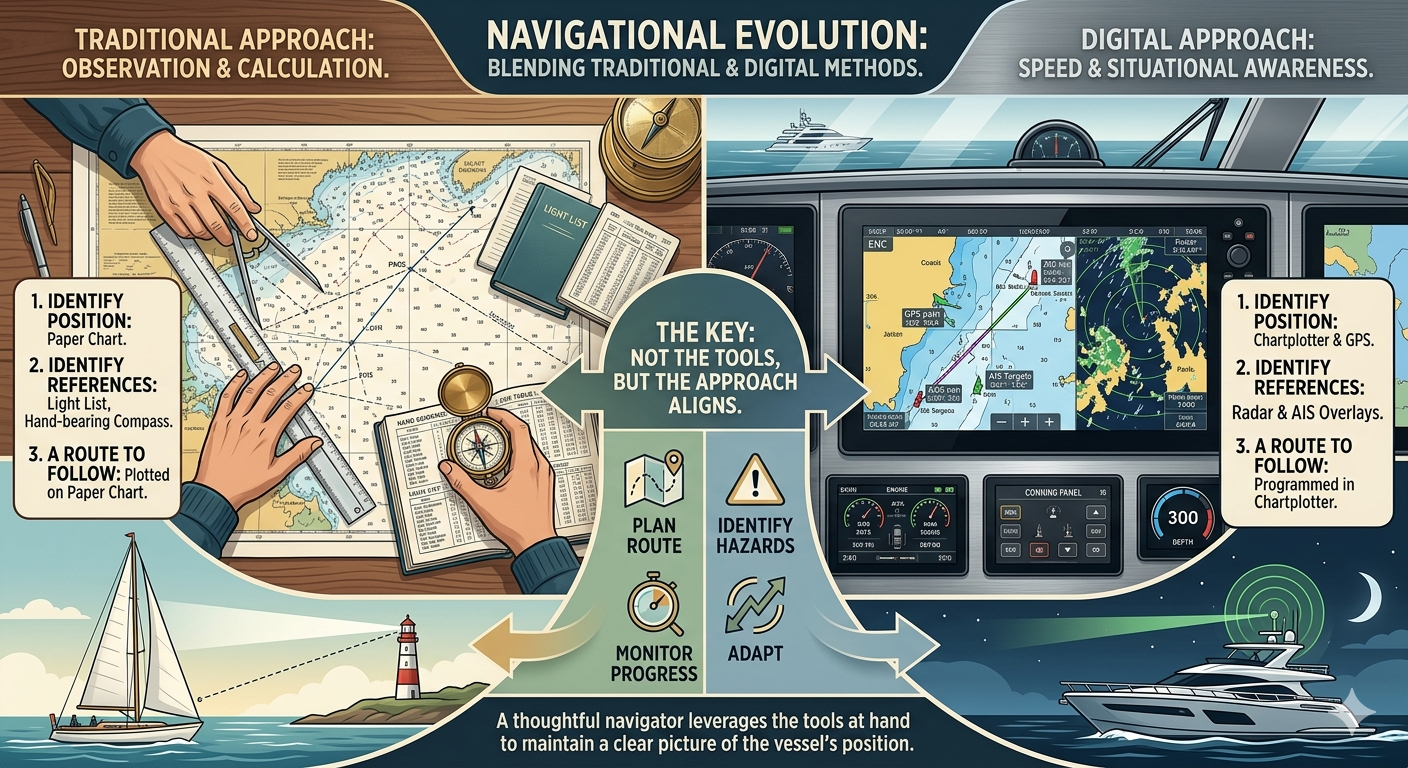
Navigation tools have evolved dramatically, and paper nautical charts are increasingly being replaced by digital systems. While traditional charts are still used by some, most modern sailors rely on electronic chart plotters, GPS, AIS, radar, and integrated navigation displays. The key is not which tools you have, but how well your navigation approach aligns with the methods you plan to use and the equipment available to you.
Keep a dedicated navigation pencil case with at least two writing utensils, preferably pencils, an eraser, and a notebook. Running out of pencils mid-passage is more common than you might think. Remember to bring a sharpener.
Ensure your hand-bearing compass is stored and used well away from ferrous metals, speakers, and electronic devices. Even a small magnetic influence can introduce significant bearing errors.
Every navigator needs these essential elements:
- A way to identify your position. Traditional sailors use plotted fixes on paper charts; digital sailors use GPS and chart plotters.
- A way to identify visual references. Traditional sailors rely on hand-bearing compasses, light lists, and visual landmarks; digital sailors can use chart plotter overlays, radar, and AIS.
- A route to follow. Both methods require planning courses, waypoints, and adjustments for hazards, tides, and currents.
Standard Tools for Traditional Sailors
- Paper nautical charts of the operating area
- Dividers and parallel rulers (or Douglas protractor) for plotting
- Hand-bearing compass
- Marine binoculars (7x50 or similar)
- Depth sounder (optional but useful)
- Tide tables and light lists
- Logbook and pencil
Standard Tools for Digital Sailors
- GPS receiver or chart plotter
- AIS for vessel tracking
- Radar (for low visibility and collision avoidance)
- Integrated weather data (optional but useful)
- Depth sounder or echo sounder
- Electronic chart updates
- Logbook (digital or traditional)
Standard Tools for Hybrid Sailors (Both Methods)
- Paper charts and plotting tools (dividers, rulers, protractor)
- Chart plotter with GPS and AIS
- Hand-bearing compass
- Binoculars
- Depth sounder
- Tide tables, light lists, and weather references
- Logbook for recording observations and fixes
- Pencil and eraser for traditional plotting alongside digital backups
For hands-on sailors, plotting courses and taking bearings manually can strengthen understanding of position, bearings, and environmental effects. For digital sailors, integrated chart plotters and GPS provide speed, precision, and situational awareness. Hybrid sailors benefit from the best of both worlds, cross-checking manual fixes against electronic readings to improve accuracy and build navigational intuition.
Regardless of your approach, the fundamentals remain the same: plan your route, monitor your position, track hazards, and adapt to changing conditions. The tools are there to support your style, not define it.
The Fix-Plan-Execute Cycle
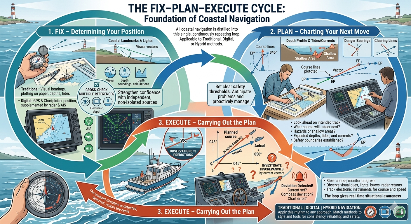
All coastal navigation can be distilled into a single, continuously repeating loop: Fix, Plan, Execute. This cycle is the foundation of safe, confident navigation, whether you rely on traditional methods, digital systems, or a combination of both.
Write your planned expectations in the logbook before you execute. For example: 'Expect to see Anvil Point Light bearing 270M at approximately 14:35.' When reality matches your plan, you know your navigation is sound.
Never skip the fix step and proceed directly to execution based on an old position. In tidal waters, even ten minutes without a fix can place you dangerously off track.
1. Fix — Determining Your Position
The cycle begins with a fix, where you determine your current position as accurately as possible. How this is done depends on the methods and tools you are using:
- Traditional sailors take visual bearings with a hand-bearing compass, identify landmarks or lights, and plot their position on a paper chart using dividers and parallel rulers. Depth soundings and tide calculations can provide additional verification.
- Digital sailors rely on GPS and chart plotters, sometimes supplemented by radar and AIS overlays, to establish an immediate position.
- Hybrid sailors may cross-check a GPS fix with visual bearings, radar, or depth readings to ensure confidence in their location.
Regardless of method, the principle is the same: never rely on a single source in isolation. Cross-checking multiple, independent references — visual, electronic, or depth-based — strengthens confidence that your position is accurate. A fix is only as reliable as the care taken to obtain it, so honesty and precision are critical: record what you actually observe, not what you hope to see.
2. Plan — Charting Your Next Move
With a reliable fix in hand, the navigator moves to the planning phase. Planning involves looking ahead along your intended track and asking key questions:
- What course will I steer next?
- Are there hazards, shallow areas, or other obstructions along the track?
- What is the expected depth profile, and how will tides and currents affect my ground track?
- When and where will the next aids to navigation appear, and on what bearing?
- What danger bearings should be established to avoid shallow areas or hazards?
For traditional sailors, planning means plotting courses on paper charts and calculating estimated positions and times. Digital sailors can program waypoints and routes directly into a chart plotter, with automated course guidance and alerts for hazards. Hybrid sailors benefit from both, plotting a mental or paper-based plan while confirming it with electronic tools.
Good planning anticipates problems before they arise, sets clear safety thresholds, and ensures that you are not reacting to circumstances but proactively managing them.
3. Execute — Carrying Out the Plan
Finally, you execute the plan by steering your course, monitoring your progress, and comparing observations with predictions. Execution is where the cycle becomes dynamic:
- Observe visual cues, lights, buoys, or radar returns.
- Monitor electronic instruments and track your course and speed.
- Take note of any discrepancies — if a lighthouse expected at 045 degrees appears at 050 degrees, investigate: is current setting you off track? Has the compass deviated? Are charted hazards accurate?
The moment a deviation is detected, the cycle restarts: take a new fix, revise your plan, and execute again. This disciplined loop, performed continuously throughout a passage, keeps a vessel safely on track and gives the navigator real-time situational awareness.
Integrating Tools and Style
No matter which tools you have, the Fix-Plan-Execute cycle applies. Traditional tools teach you observation, plotting, and mental modeling; digital tools provide speed, precision, and real-time situational awareness; hybrid approaches combine both for maximum confidence. The navigator's task is to match the methods to their style and tools, ensuring that every fix, plan, and execution is consistent, reliable, and safe.
By thinking in terms of Fix, Plan, Execute, sailors maintain a rhythm that keeps them in control, regardless of whether they are plotting on paper, monitoring a chart plotter, or doing both.
What are the three phases of the Fix-Plan-Execute cycle, in order?
A navigator expects to see a lighthouse bearing 045 degrees but observes it at 050 degrees. What is the correct response?
Summary
Coastal navigation is the art and science of guiding a vessel safely along a coastline, typically within 20-30 nautical miles of shore, using charts, visual references, and navigational aids.
It is an active, continuous process: the proximity of hazards like shoals, reefs, shifting sandbars, and vessel traffic requires frequent position checks and ongoing situational awareness.
Two complementary tool sets exist: traditional methods (paper charts, compass, visual bearings, plotting tools) and electronic systems (GPS, chart plotter, AIS, radar). Most navigators use a blend of both.
Every navigator needs three things: a way to identify position, a way to identify visual references, and a route to follow — regardless of whether those come from paper or digital tools.
The Fix-Plan-Execute cycle is the core workflow: determine your position, plan the next leg with hazard and tidal awareness, execute while monitoring for deviations, and repeat continuously throughout the passage.
When observed conditions don't match the plan, restart the cycle immediately — take a new fix, revise the plan, and execute again.
Key Terms
- Coastal Navigation
- The art and science of guiding a vessel safely along a coastline, typically within 20-30 nautical miles of shore, using charts, visual references, and navigational aids.
- Fix
- A confirmed position on the chart, obtained by crossing two or more independent position lines — from visual bearings, GPS, radar ranges, or depth — to verify location.
- Dead Reckoning (DR)
- Estimating a vessel's current position by advancing a known position using course steered and distance logged, without accounting for external forces like current or leeway.
- ATON (Aids to Navigation)
- Fixed or floating markers — buoys, beacons, lighthouses, and leading marks — placed by authorities to help navigators determine position and avoid hazards.
- AIS (Automatic Identification System)
- A transponder-based system used by vessels to broadcast and receive position, speed, course, and identity data, improving collision avoidance and situational awareness.
- Headland
- A prominent point of high land that projects into the sea. Headlands are commonly used as landmarks for visual navigation and bearing fixes.
- Draft
- The vertical distance from the waterline to the lowest point of a vessel's keel. A vessel's draft determines the minimum water depth required for safe passage.
- Chartplotter
- An electronic navigation device that combines a GPS receiver with a digital chart display, showing the vessel's real-time position overlaid on the chart.
- Clearing Bearing
- A predetermined bearing to a charted object that, when maintained, keeps the vessel clear of a specific hazard or danger area.
- Danger Bearing
- A bearing to a charted object beyond which a vessel must not pass — used as a safety limit when navigating near hazards.